(Optionally, click on this image for a larger view)
Tuesday, March 30, 2010
Otter Lake Road
There are a series of many beautiful small lakes and ponds in the St. Marks Refuge north and south of Otter Lake. The Refuge web site relates "Boats with over 10 h.p. motors are prohibited on all the Panacea Unit of the Refuge. Gates (road 316) on Otter Lake Rd. will be opened for fishing access from March 15 – May 15 each year." The gates that are unlocked are at the game check station on the Otter Lake Road, before (= east of) the Otter Lake boat ramp/picnic area.
Monday, March 29, 2010
Purified
Although rather strenuous, the hike eastward along the coast from Purify Creek is one of my favorites to see the salt marsh.
To get there: From Highway 98 in Medart opposite Mikes Paint & Body shop, turn south onto Jack Crumb Road. At the turn to the left, go straight heading south on Purify Road. Near the end of Purify Road, the St. Marks Refuge provides parking on the left at intersection with the Florida Trail.
(Wearing high rubber boots) I walk eastward along the Florida Trail. Where the trail approaches the marsh within 50 yards to the south, I walk through the trees to the marsh, then walk eastward along the edge of the salt marsh toward Spring Creek. The red line is my approximate route on the Google Map below, where green is forest, grey is marsh, and black is water. Actually most of this coastline is wet land and water.

The sun rose through the pines and palmettos along the Florida Trail.

Ahhhh ... 45 degrees cool and blue blue skies.


Looking through limbs of cedar tree to a pine snag quite a distance out in the salt marsh.

Green resurrection fern on an oak tree

Seeds and new leaves of red maple floating in water ... the white specs in the water are pollen.

This abstract intrigues me: Sunlight filtering through the trees created patterns of light and dark; tree and blue sky reflections; and the limb pointing at a curious patch in the water without pollen.

(Optionally, click on an image for a larger view)
To get there: From Highway 98 in Medart opposite Mikes Paint & Body shop, turn south onto Jack Crumb Road. At the turn to the left, go straight heading south on Purify Road. Near the end of Purify Road, the St. Marks Refuge provides parking on the left at intersection with the Florida Trail.
(Wearing high rubber boots) I walk eastward along the Florida Trail. Where the trail approaches the marsh within 50 yards to the south, I walk through the trees to the marsh, then walk eastward along the edge of the salt marsh toward Spring Creek. The red line is my approximate route on the Google Map below, where green is forest, grey is marsh, and black is water. Actually most of this coastline is wet land and water.

The sun rose through the pines and palmettos along the Florida Trail.

Ahhhh ... 45 degrees cool and blue blue skies.


Looking through limbs of cedar tree to a pine snag quite a distance out in the salt marsh.

Green resurrection fern on an oak tree

Seeds and new leaves of red maple floating in water ... the white specs in the water are pollen.

This abstract intrigues me: Sunlight filtering through the trees created patterns of light and dark; tree and blue sky reflections; and the limb pointing at a curious patch in the water without pollen.

(Optionally, click on an image for a larger view)
Tuesday, March 23, 2010
Celebrating Wildlife and the Environment Last Weekend
I don't have to tell you how fine the 2010 Wakulla Wildlife Festival was, because if you live near Tallahassee you were probably there. Over 2,000 people shared their passion for the environment during the festival at the Wakulla Springs State Park on Friday and Saturday.
No doubt millions of photos were taken during the festival boat tours. Here are some of my favorites.
During their nesting season, male and female anhingas develop an attractive aquamarine color around their eyes.

Profile of a barred owl.

A pair of great egrets are nesting in a cypress tree along the boat tour.


Looking into the golden light

Mist rising from Springbasin during the Sunrise Serenity boat tour

(Click on any photo to get a full screen view. )
No doubt millions of photos were taken during the festival boat tours. Here are some of my favorites.
During their nesting season, male and female anhingas develop an attractive aquamarine color around their eyes.

Profile of a barred owl.

A pair of great egrets are nesting in a cypress tree along the boat tour.


Looking into the golden light

Mist rising from Springbasin during the Sunrise Serenity boat tour

(Click on any photo to get a full screen view. )
Thursday, March 18, 2010
Wakulla Springs Without Preconceptions
I strive to live life with eyes wide open, without preconceptions ...
to see LIGHT WAVES.

and to experience the magic. The glowing edges photoshop filter revealed MYSTERIOUS patterns in the water of the spring basin.

PLANTS-LIKE-EELS (and Eels-like-plants).

Is less more in a Gator's SCARY, SCALY SMILE?


The Eyes have it ... little BLUE heron EYES OF GOLD.
Optionally, click any image to see a larger version.
to see LIGHT WAVES.

and to experience the magic. The glowing edges photoshop filter revealed MYSTERIOUS patterns in the water of the spring basin.

PLANTS-LIKE-EELS (and Eels-like-plants).

Is less more in a Gator's SCARY, SCALY SMILE?


The Eyes have it ... little BLUE heron EYES OF GOLD.

Optionally, click any image to see a larger version.
Ducks at St. Marks
I photographed these two redhead ducks and the single ring-necked duck from my car along the Lighthouse Road in the St. Marks Refuge late Monday afternoon.

(Click on the image to view it larger.)

(Click on the image to view it larger.)
Monday, March 15, 2010
Alligator Point Is The Closest Sand Beach For A Long Walk
These photos were taken yesterday during a three-hour walk on the Alligator Point shoreline.
Driving Directions: About 2 miles south of the Ochlocknoee River, turn to the left (= east) off of US Highway 98 onto State Road 370 (= Alligator Road). Keep to the right to continue on Alligator Road as it turns to the right, at its intersection with the Bald Point Road on the left. Continue driving westward about 4 miles on Alligator Road to a small parking lot with beach access on the left (= south), just before a house at 1520 Alligator Road.
I always walk to the right (= west) from the beach access. This is the long sandy beach at low tide.

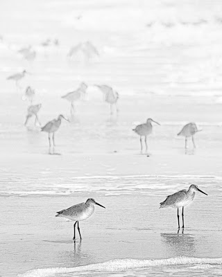
These willets have striking black and white bars on their wings that are visible only in flight; I've always thought their call sounds like, Will-it? Will-it? Will-it?

Driving Directions: About 2 miles south of the Ochlocknoee River, turn to the left (= east) off of US Highway 98 onto State Road 370 (= Alligator Road). Keep to the right to continue on Alligator Road as it turns to the right, at its intersection with the Bald Point Road on the left. Continue driving westward about 4 miles on Alligator Road to a small parking lot with beach access on the left (= south), just before a house at 1520 Alligator Road.
I always walk to the right (= west) from the beach access. This is the long sandy beach at low tide.

These willets have striking black and white bars on their wings that are visible only in flight; I've always thought their call sounds like, Will-it? Will-it? Will-it?

Sunday, March 7, 2010
Wednesday, March 3, 2010
Grackle and Great Egret at St. Marks Lighthouse
Late Sunday afternoon, I drove through the the St. Marks National Wildlife Refuge to the end of the Lighthouse Road.
I made another deposit of smiles to years of satisfying experiences in the refuge: Rafts of coots feeding, ducks in the distance, two great egrets, irradescent grackles, gulls spiraled overhead, a northern harrier flew low over the salt marsh, and six deer.
Alpha Boat-tailed Grackle
Great Egret Flying Into The Setting Sun

Info on photo above: Camera Canon 40D; Lens Canon EF75-300mm f/4-5.6 IS USM; Focallength 140mm; ISO 200; Shutterspeed 1/1000 second; Aperture 71/10 (approximately F8); Raw file cropped converted in CS4 to JPG
Monday, March 1, 2010
Coasting in Wakulla
Last Saturday, I first walked St. Marks Refuge Road #217 that connects the road to Shell Point with the road to Live Oak Island. I soon encountered two huge hogs with at least a dozen small pigs rooting and snuffling in the road while searching for food.

Then, I walked the St. Marks Refuge Road #218 from the road to Live Oak Island to the West Goose Creek Seine Yard. Little remains of the buildings and observation tower of this once active enterprise where mullet were caught in nets on the western shoreline of Goose Creek Bay. The coastal hammocks here are amazing, with red cedar and palms. (If you go to seine yard, be advised that the northern side of Road #218 is closed during the bald eagle nesting season, which I believe is October 1 through May 15). I walked to the Gulf shoreline then south, where I took the following photos.
By the time I got back to the car, it was time for lunch. So I drove to the Riverside Cafe in St. Marks, where I always enjoy their fish sandwiches and the view of the St. Marks River, including grackles, gulls, and pelicans.
Subscribe to:
Posts (Atom)


